Blucher Park – BioBlitz March 2026
iNaturalist Project: https://www.inaturalist.org/projects/blucher-park-bioblitz-march-2026
The BioBlitz is a citizen science project hosted by the South Texas Master Naturalist Chapter. Master Naturalists participating in this project should enter their hours in VMS as Citizen Science – FR:TMN Field Research Hours.
A kick-off/orientation meeting will be held on March 1st, 2026 (1 pm to 4 pm). We will spend a short time covering project logistics, assigning survey sectors, and providing data collection guidelines.
We will be using the iNaturalist app and website to compile observations. We are striving for data quality over quantity. Identification of species by iNaturalist is enhanced by good quality photos, which encompass most of your phone screen or camera viewfinder.
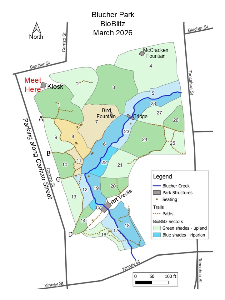
We will assign you to one or more BioBlitz sectors during the March 1st meeting at the park. We will meet at the Kiosk, at the corner of Carrizo and Blucher. It is OK to conduct your surveys alone or in pairs. There are 28 survey sectors – many are delineated by either trails or the creek. The map is color-coded to help differentiate between each sector. The upland sectors are rendered in shades of green and the sectors adjacent to Blucher Creek are rendered in shades of blue. See map at bottom of page.
Project coordinators will be available from 1 pm to 4 pm to assist with iNaturalist, help identify the general boundaries of the survey sectors, and answer any other questions you might have.
If you cannot attend the March 1st meeting, you can still participate in the BioBlitz. If you choose to do so, please send an email to [email protected] so we can let you know which survey sectors need additional observations.
After March 1st, go to the park as many times as you can the rest of the month and spend at least 15-30 minutes in your assigned survey sector, collecting data. After you collect data in your sector, please feel free to roam the park and collect additional observations. This will increase your chances of encountering birds and other fauna that might not be present in your survey sector.
There are several mobile versions of iNaturalist, depending on your phone’s operating system. Either version will work for this project. Feel free to monitor progress of the BioBlitz on iNaturalist – click on the Map icon to see where observations have been collected.
NOTE: use caution when collecting observations under heavy tree cover. The branches and leaves can interfere with GPS satellite signals and lead to inaccurate location coordinates. It is possible to edit the location later in iNaturalist.
There is a KML file (for Google Earth or Google Maps) available to download to your mobile device or laptop/desktop, that shows the boundaries of each survey sector. TO RECEIVE THE KML FILE, please email [email protected] and request the file (sadly, we cannot post it here).