The Nueces River. Our river. The river that flows through Hazel Bazemore Park. The river that empties into the Nueces Bay via Nueces Delta Preserve. But where does it come from?
My husband and I subscribe to the Texas Highways magazine. On the cover of the July issue, there was a beautiful picture of the Nueces River and a lengthy article about our river. The picture did not look anything like the river we see alongside Interstate 37, so we decided to make a day trip to see where this photo came from.
We came up with three different routes and chose to take Highway 72 through Tilden before heading farther north. We were able to see Choke Canyon Reservoir, which was a good geography lesson for me since I thought that body of water was on the other side of Interstate 37. (Some of you know that I am geographically challenged, but that is another story!) The countryside became slightly rolling hills, and we enjoyed seeing the milo, soybeans, cotton, hay, cattle, and horses alongside the road. The limestone rocks began appearing in the fields, and there were bigger hills (mountains?) too, so we knew we were getting closer to our destination.
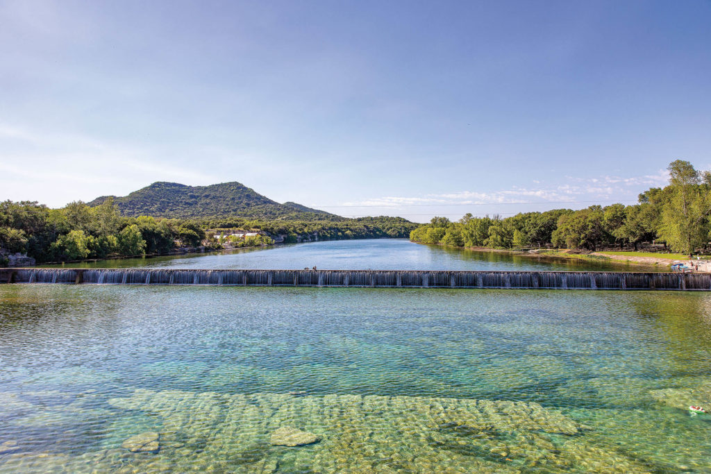
At Uvalde, we took Highway 55 north to Camp Wood and, to our delight, found the Nueces River to be as clear and blue as the snapshot on the magazine cover. At Wes Cooksey campground, we walked along the bank of the river where we watched an immature Yellow-crowned Night -Heron eating a fish. The dam/waterfall there was around 10’ tall. People were floating and swimming on both sides of the dam. Right next to the campsites, we figured out how to get to the parking area underneath the highway bridge, and found a dozen or so families with their lawn chairs sitting on the rock bottom of the river and enjoying the cool water. There was a low water crossing, with 2’ pipes under the road, and we watched one poor dog lose his tennis ball as it was sucked through the aqueduct.
The river is spring-fed with a limestone bottom. It is crystal clear and clean. The Texas Highways magazine explained that the reason for the clarity is because there are almost no nutrients, i.e. nitrogen and phosphorous, in the river. The towns along the Nueces headwaters use their soil, through proper land application, for their wastewater disposal and don’t discharge anything into the river. Amazingly good stewardship! Also, the rivers to the east of the Nueces River (like the Frio,) host most of the campers, tubers, and swimmers, so the Nueces River has way fewer people around it.
Though our day lasted longer than we expected, we had a great time and would highly recommend it. And if you are looking for lunch along the way, King’s Texas Smokehouse in Camp Wood has a sandwich called “The Beast” that is awesome!!!
Cindy Frank, Texas Master Naturalist