The Welder Wildlife Foundation (WWF) encompasses a variety of landscapes associated with a transition from the plains of the Gulf Coast Prairie natural region to a typical coastal estuary system. The variety of features distinguishes the Welder Wildlife foundation from other locales in the South Texas Chapter. Here we see several expressions of riparian (stream) environments and habitats for diverse plant and animal life.
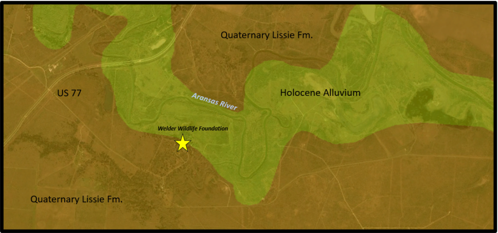
The underlying geological strata for the greater part of the WWF is the “Lissie Formation,” a mid-Pleistocene (1.2 million years old) layer of sand, silt, and clay deposited on a coastline, not unlike our present day. The elevation of the plain at 40 ft. suggests that sea level was near that level during the deposition of these Lissie strata.
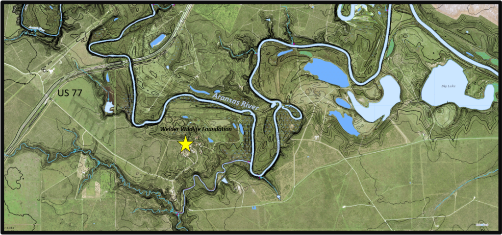
The Aransas River courses as the northern boundary of the Foundation and as the county line between San Patricio and Refugio. It is a mature stream entrenched approximately 20-30 ft. and it has well-developed terraces that step down into the present river channel. Along the river valley, there are abandoned segments of ancient channels that are filled with water called “oxbow” lakes. In other places the old riverbed is dry. Some oxbows have been mined for gravel and sand deposits creating larger man-made features such as “Big Lake” and swampy areas attractive to wildlife. The Aransas River and Chiltipin Creek coalesce at a single bayhead delta as they flow into Copano Bay.
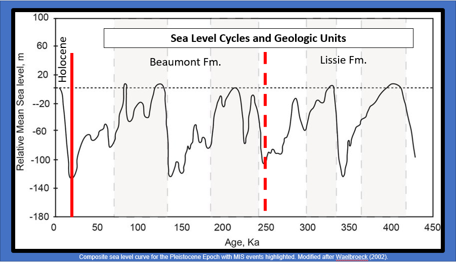
Over the last million years, the Texas coast has experienced multiple repetitive and extreme rises and falls of sea level as the Earth has generally cycled cooler. The extreme and rapid cyclicity of sea-level change is indicated in the entrenchment of the Aransas River with numerous terraces and abandoned channels. The present-day river is slow-moving because the modern Holocene rise in sea level has resulted in a very low steam gradient near the coast. Under normal conditions, the river transports only fine-grained muds and silts. During high stages, the short Aransas River can flood extensively and flow violently in its narrow valley – but it clears quickly into the large Copano Bay.
Five Things to Notice
- At the main house, notice that you are standing on generally flat land. This riparian upland is the Lissie Formation at your feet. The Lissie Formation and younger Beaumont Formation form the typical thicketed mesquite and grass prairie of the coastal plain. The oaks and hardwoods to the north increase towards the lowlands of the Mission River.
- On the drive to the Aransas river, notice stepping down elevation towards the river valley lowland. The vegetation changes from grassland prairie to lowland hardwood.
- On the riparian walk to the river, notice the slope changes and tiers of vegetation affected by stages and intensity of flood. At the river, the bank is steep (and often slippery). You will walk across abandoned channels, sand bars, and dry oxbows on the loop back to the vehicles.
- This extremely productive and protected landscape was most certainly attractive to Native Americans. Consider the possible resources available in this area and the easily navigable proximity to the bounty of Copano Bay. Why might there be so many clam shells scattered in the soil on the terraces of the Aransas River?
- On the loop drive, note how steep the bank is on the tributary south of the main house. On this trip, you will observe the oxbow lake features and mining operations of the prior owners. Note how nature recovers the landscape.
4/29/2020
Randy Bissell
Texas Master Naturalist & Texas Professional Geoscientist