| Brazosmaps is a compilation of links to maps of interest to members of the following organizations: • Brazoria County Parks Department • Friends of Brazoria Wildlife Refuges • Texas Master Naturalist Cradle of Texas Chapter First-time users click here. Report broken links; suggest a map. |
Revised 2019-03-26
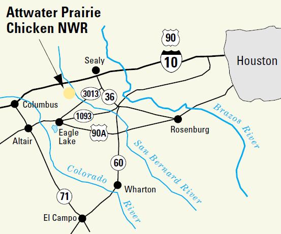
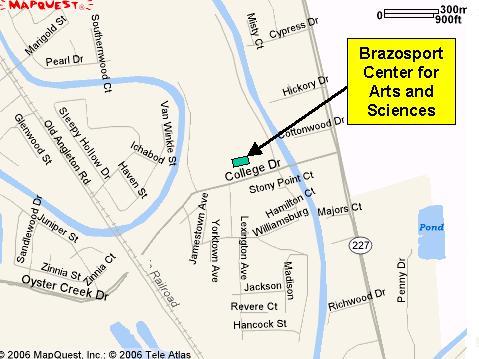
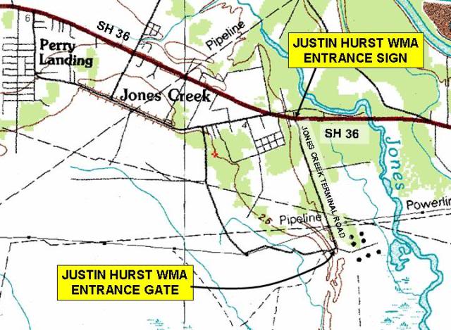
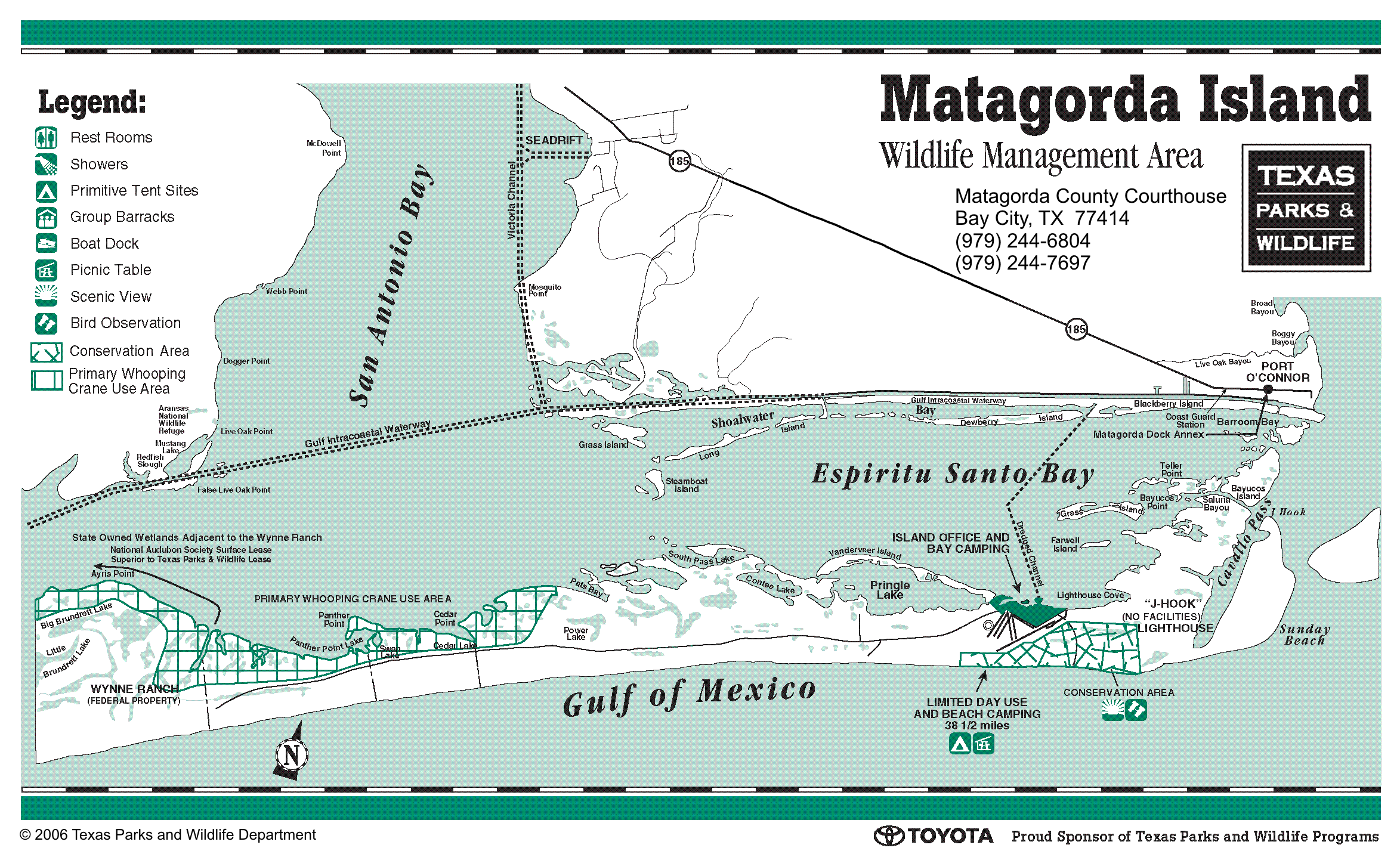
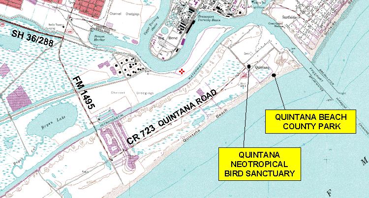
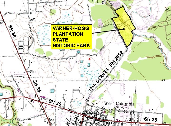
| Abner Jackson Plantation• See Lake Jackson Plantation Adriance Library• See Brazora County Historical Museum Agrilife Extension• See Texas A&M AgriLife Extension Service Albert Finkle Memorial County Park• 281-756-1541 (Alvin number)• 979-388-1541 (Brazosport number)• 979-864-1541 (Angleton number)• VPAL [TMN-COT]• Website [BCPD]• Road map [Google]• GPS: 29.302359,-95.267486 Alden Dow Office Museum• 101 S. Parking Place, Lake Jackson, TX 77566• 979-297-1570 (Lake Jackson Historical Museum)• Website [LJHM]• Website [Wikipedia]• Road map [Google]• GPS: 29.302352, -95.26747 Alligator Marsh Waterfowl Hunt Area• See Brazoria National Wildlife Refuge Alvin Community College• 3110 Mustang Road, Alvin Texas 77511• 281-756-3500• History [Handbook of Texas]• Website [ACC]• Website [Wikipedia]• Facebook [ACC]• Campus Map [ACC]• Road map [Google]• GPS: 29.3979919, -95.2434826 Alvin Library• 105 South Gordon, Alvin, TX 77511• 281-388-4300• Website [BCLS]• Road map [Google]• GPS: 29.4235606, -95.2439627 Alvin Museum Society • 300 West Sealy Street, Alvin, TX 77511 • Website • Road map [Google] • GPS: 29.423918, -95.2460146Marguerite Rogers House Museum• 281-585-2803 • 113 East Dumble Street, Alvin, TX 77511 • Website • Road map [Google] • GPS: 29.4169278, -95.2432036 AMS operates two museums Alvin Senior Center• 309 West Sealy, Alvin, Texas 77511• 281-388-4298• Website [City of Alvin]• Road map [Google]• GPS: 29.42374,-95.246427 Angleton Library• 401 E. Cedar, Angleton, TX 77515• 281-756-1519 (Alvin number)• 979-388-1519 (Brazosport number)• 979-864-1519 (Angleton number)• Website [BCLS]• Road map [Google]• GPS: 29.1695314, -95.4316503 Angleton School History Center• 1800 N. Downing Road, Angleton, TX 77515-3711• 979-864-8015• Website• Facebook• Road map [Google]• GPS: 29.177423, -95.419032 Archeology• See Brazosport Archaeological Society Armand Bayou Nature Center• 8500 Bay Area Blvd., Pasadena, Texas 77507• 281-474-2551• Website [ABNC]• Trail map [ABNC]• Road map [Google]• GPS: 29.5987412, -95.0748038 Astronomy• Club – See Brazosport Astronomy Club• Observatory – See George Observatory• Planetarium – See BASF Brazosport Planetarium Attwater Prairie Chicken National Wildlife Refuge• P.O. Box 519, Eagle Lake, TX 77434-0519• 979-234-3021• Website [USFWS]• CBC Bird Count [TMN-COT)• Road Map [USFWS]• Road Map [Google]• GPS: 29.647929,-96.256399 Austin• County Park – See Steven F. Austin-Munson Historical County Park • Statue – See Steven F. Austin-Munson Historical County Park • Town – See Austin Town Site Austin Town Site• 281-756-1208 (Alvin number)• 979-388-1208 (Brazosport number)• 979-864-1208 (Angleton number)• Website [BCHM]• Road map [Google]• See also Brazoria County Historical Museum• GPS: 29.2598949, -95.4583812 Avian Conservation Science Center• See Gulf Coast Bird Observatory BASF Planetarium A member group of the Center for the Arts and Sciences• 979-265-3376• VPAL [TMN-COT]• Website [BCFAS]• Facebook [Facebook]• Astronomy Club [BCFAS]• Description of Projector [TMN-COT] • Maps and GPS – see BCFAS Baytown Nature Center• 6213 Bayway Dr, Baytown, TX 77520• 281-424-9198• Website [Friends of BNC]• Website [Wikipedia]• Facebook [Friends of BNC]• Road map [Google]• GPS: 29.7549,-95.035516 BEES• See Brazoria County Master Gardeners Association Betty Brown Unit of SBNWR• 979-964-4011 (Mid-coast NWR office)• 979-964-3639 (SBNWR office)• Website [FOBWR]• Species Survey [Kneupper et al]• Road map [Google]• GPS: 28.9587287, -95.5556045 Big Boggy National Wildlife Refuge• 979-964-4011 (Mid-Coast NWR office)• 979-964-3639 (SBNWR office)• History [Handbook of Texas]• Website [USFWS]• Refuge map [USFWS]• Annotated road map [FOBWR]• Road map [Wikimapia]• GPS: 28.7483186, -95.8119393 Big Slough Recreation Area• See Brazoria National Wildlife Refuge Big Tree The so-called “Big Tree” is correctly known as the “San Bernard Oak.” It is the largest Live Oak (Quercus virginiana) in Texas. It is located at the San Bernard National Wildlife Refuge.• See San Bernard National Wildlife Refuge Bird, Birding• Brazosport Birders• Christmas Bird Counts• Dow Black Skimmer Colony• Gulf Coast Bird Observatory• Matagorda Birding & Nature Center• Quintana Neotropical Bird Sanctuary• Smith Point Hawk Watch Boat Ramps• Annotated Map [Brazoria County Parks Department] Bobcat Woods Trail• See San Bernard National Wildlife Refuge Brazoria Bird Count• Website [TMN-COT]• CBC Circle Map [PDF] Brazoria Civic Center Brazoria Civic Center is the home of the Brazoria Heritage Foundation the Brazos Valley Railroad Museum and the Brazoria Chamber of Commerce• 202-208 West Smith Street, Brazoria, TX 77422• 979-798-6100 (Chamber of Commerce)• 979-798-1414 (BHF Box office)• Road map [Google]• See Brazoria Chamber of Commerce• See Brazoria Heritage Foundation• See Brazos Valley Railroad Society• GPS: 29.0467157, -95.5710661 • See Brazoria Heritage Foundation Brazoria County Airport• See Texas Gulf Coast Regional Airport Brazoria County Boat Ramps• Annotated Map [BCPD] Brazoria County Courthouse• 111 E. Locust St., Angleton, Texas 77515-4642• Website [Brazoria County]• Facebook [Facebook]• Road map [Google]• GPS : 29.1679576, -95.432868 Brazoria County Courthouse East Annex• 1524 E Mulberry, Angleton TX 77515.• Road map [Google]• GPS : 29.175162,-95.414427 Brazoria County Courthouse West Annex• 451 N. Velasco, Angleton, TX 77515• Road map [Google]• GPS : 29.1679576, -95.432868 Brazoria County Fairgrounds• 901 S Downing Rd, Angleton, TX 77515• 979-849-6416• Website• Road map [Wikimapia]• GPS : 29.1553815, -95.4184399 Brazoria County Historical Museum• 100 East Cedar Street, Angleton, TX 77515• 281-756-1208 (Alvin number)• 979-388-1208 (Brazosport number)• 979-864-1208 (Angleton number)• Website [BCHM]• Adriance Library [BCHM]• Facebook [Facebook]• Road map [Google]• GPS: 29.1695127, -95.4316127 Brazoria County Library System • Brazoria Library • Clute Library • Danbury Library • Freeport Library • Lake Jackson Library • Manvel Library • Pearland Library • Pearland Westside Library • Sweeny Library • West Columbia Library For branch libraries, see box • Administrative office 451 N Velasco Street, Suite 250 (West Annex) Angleton 77515-4442 281-756-1505 (Alvin number) 979-388-1505 (Brazosport number) 979-864-1505 (Angleton number)• Website [BCLS]• Environmental Education Program [TMN-COT]• Facebook [Facebook]• Road map [Google]• GPS: 29.167995,-95.432705 Brazoria County Master Gardeners Association Open hours may vary. Call the number listed below for current information.• 21017 County Road 171, Angleton, TX 77515-8903 • 281-756-1558 Ext 119 (Alvin and north) • 979-388-1558 Ext 119 (Brazosport and south) • 979-864-1558 Ext 119 (Angleton and west) • Road map [Google] • GPS: 29.174869,-95.405333Brazoria Environmental Education Station (BEES)• Open Tuesday and Friday morningsOpen other times as announced. Call the number below or the extension office for information. Or just show up ― if the gate is open, BEES is open.• 585 CR443 (Hospital Drive) at CR 171, Angleton, Texas • 979-549-9903 • Road map [Google] • Historic property map [TAMU] • GPS: 29.185559,-95.391203 For operating hours, see box Brazoria County Parks Department • Brazos River County Park • Buffalo Camp County Park • Camp Mohawk County Park • Hanson Riverside County Park • Quintana Beach County Park • Resoft County Park • San Luis Pass County Park • Steven F. Austin-Munson Historical County Park • Surfside Jetty County Park For individual parks, see box • Administrative office 313 West Mulberry Street Angleton, TX 77515-4341 281-756-1541 (Alvin number) 979-388-1541 (Brazosport number) 979-864-1541 (Angleton number)• Website [BCPD]• Facebook [Facebook]• Road map [Google]• GPS: 29.1642101, -95.4353678 Brazoria Environmental Education Station (BEES)• See Brazoria County Master Gardeners Association Brazoria Heritage Foundation• 202 West Smith Street, Brazoria, TX 77422• 979-798-1414 (Box office)• Website [BHF]• Facebook [Facebook]• Road map [Google]• See also Brazos Valley Railroad Society• GPS: 29.0467157, -95.5710661 Brazoria Library• 620 South Brooks, Brazoria, TX 77422• 979-798-2372• Website [BCLS]• Road map [Google]• GPS: 29.0408722, -95.5695856 Brazoria National Wildlife Refuge • 2022 County Road 227, Freeport, Texas, 77541 • Website [FOBWR] • DEEP Environmental Education [TMN-COT] • Annotated Map [FOBWR] • Road Map [Google] • GPS: 29.059963, -95.268216Big Slough Recreation AreaOpen sunrise to sunset every day. • 2022 County Road 227, Freeport, Texas, 77541 • Big Slough Auto Tour [USFWS] • Big Slough Hiking Trail [USFWS] • Cox Lake Hiking Trail [USFWS] • Maddox Cedars [FOBWR] • Road Map [Google] • GPS: 29.065248, -95.319300Alligator Marsh Waterfowl Hunt AreaOpen during specified hunt days only. • Road map [USFWS] • Road map [Google] • GPS: 29.1268035, -95.24418Refuge Field Office and Otto Slough TrailOpen 7:00AM – 5:30PM Monday-Friday • 24907 FM, Angleton TX 77515-2157 • 979-922-1037 • Road map [Google] • GPS: 29.153754,-95.299126 For operating hours, see box Brazos Bend State Park• 21901 FM 762 Needville, TX 77461• 979-553-5102 (park office) or 512-389-8900 (reservations)• VPAL [TMN-COT]• Website [TPWD]• Website [BBSP Volunteer Organization]• Facebook [Facebook]• Video [TPWD]• Facilities map [TPWD]• Trail map [TPWD]• Facilities map [TPWD]• CBC Circle Map [JPG] [Bill Godley]• Road map [Google]• GPS: 29.3714421, -95.6412435 Brazos River County Park• 281-756-1541 (Alvin number)• 979-388-1541 (Brazosport number)• 979-864-1541 (Angleton number)• VPAL [TMN-COT]• Website [BCPD]• Road map [Google]• GPS: 29.1137379, -95.6758332 Brazos Valley Railroad Society Museum• 208 West Smith Street, Brazoria TX 77422• 979-798-8114 [Saturday only]• 979-922-4556 [Jim Williams]• Website [BVRS]• Facebook [Facebook]• Road map [Google]• See also Brazoria Heritage Foundation• GPS: 29.0466735, -95.5714685 Brazos Woods Preserve The Nature Conservancy• 1080 County Road 645, West Columbia, TX 77486• Map with directions (TNC)• Road map (Google)• GPS: 29.11251, -95.61815 Brazosport Archaeological Society An affiliate organization of the Brazosport Center for the Arts and Sciences• 979-265-7831• Website [BCFAS]• Maps and GPS – see BCFAS Brazosport Art League A member group of the Center for the Arts and Sciences• 979-265-7661• Website [BCFAS]• Facebook [Facebook]• Maps and GPS – see BCFAS Brazosport Astronomy Club An affiliate organization of the Brazosport Center for the Arts and Sciences• 979-265-7661• Website [BCFAS]• Facebook [Facebook]• Maps and GPS – see BCFAS Brazosport Birders• Facebook [Facebook]Brazosport Center for the Arts & Sciences • Brazosport Art League • Brazosport Center Stages • Brazosport Symphony Orchestra • Brazosport Museum of Natural ScienceNature Trail• NCAP Nature Trail Affiliate Organizations• Brazosport Astronomy Club • Brazosport Archaeological Society • Sea Shell Searchers of Brazoria County For constituent organizations, see box Brazosport Center Stages A member group of the Brazosport Center for the Arts and Sciences• 979-265-7661• Website [BCFAS]• Facebook [Facebook]• Maps and GPS – see BCFAS Brazosport College – Community Education Center – Freeport• 211 East Park Avenue, Freeport, TX 77541• 979-230-3600• VPAL [TMN-COT]• Website [BC]• Road map [Google]• GPS: 28.9499546, -95.3457874 Brazosport College – Main Campus• 500 College Drive, Lake Jackson, TX 77566• 979-230-3000• VPAL [TMN-COT]• History [Handbook of Texas]• Website [BC]• Website [Wikipedia]• Facebook [Facebook]• Campus map [BC]• Road map [Google]• GPS: 29.0449899, -95.4076231 Brazosport Museum of Natural Science A member group of the Center for the Arts and Sciences• 979-265-7831• Website [BCFAS]• Facebook [Facebook]• Maps and GPS – see BCFAS Brazosport Planetarium• See BASF Planetarium Brazosport Symphony Orchestra A member group of the Center for the Arts and Sciences• 979-265-7661• Website [BCFAS]• Facebook [Facebook]• Maps and GPS – see BCFAS Bryan Beach• Website [Texas Explorer]• Map [Google]• GPS: 28.9160342, -95.3377676 Buffalo Bayou Park Not to be confused with Sabine-to-Bagby Promenade• Between Allen Parkway and Memorial Drive, from Shepard Drive and Sabine Street, Houston, Texas• 832-395-7000• Website [Houston Parks and Recreation Department]• Website [Buffalo Bayou Partnership]• Road Map [Google]• GPS: 29.761653,-95.393741 Buffalo Camp County Park• 281-756-1541 (Alvin number)• 979-388-1541 (Brazosport number)• 979-864-1541 (Angleton number)• VPAL [TMN-COT]• Website [BCPD]• Road map [Google]• GPS: 29.0625891, -95.485509 Camp Mohawk County Park• 110 County Road 193, Alvin, TX 77511• 281-581-2319 or 877-226-7664• VPAL [TMN-COT]• Website [BCPD]• History (1990) [Brazoria County Old Timers Association]• Flora Census (2008) [TMN-COT]• Park map [BCPD]• Road map [Google]• GPS: 29.3345531, -95.2854484 Candy Abshier Wildlife Management Area• 10 Parks & Wildlife Drive, Port Arthur, TX 77640• 409-736-2551• Website [TPWD]• Hawk Watch [GCBO]• Road map [Google]• GPS: 29.528415,-94.770344 Capitol of Texas Park• 979-345-3123 (City of West Columbia)• Website [City of West Columbia]• Road map [Google] Carbide Park• 4102 FM 519, La Marque, Texas 77568• 409-934-8100• Website [Galveston County]• Annotated road map [TMN-COT]• Annotated road map [TMN Galveston Bay Chapter]• Road map [Google]• GPS: 29.3579028, -95.0022554 Carolyn Raizes Davis Sanctuary• County Road 197 at Union Pacific track.• Website [Houston Audubon]• Annotated road map [Houston Audubon]• Road Map [Wikimapia]• GPS: 29.3084499, -95.266744 Cedar Lake Creek Paddling Trail• See San Bernard National Wildlife Refuge Centennial Park• See Dow Centennial Bottomlands Park Challenger Seven Memorial Park• 2301 West Nasa Boulevard, Webster, TX 77598• 713-440-1587• Website [Harris County Precinct One]• Road Map [Google]• GPS: 29.513916, -95.143065 Christmas Bird Counts• Website [FOBWR]• Attwater NWR [FOBWR]• Brazoria [FOBWR]• Brazos Bend State Park [FOBWR]• Freeport [FOBWR]• Matagorda Co. – Mad Island Marsh [FOBWR]• San Bernard NWR [FOBWR] Clear Lake Ecological Services Field Office• 17629 El Camino Real #211, Houston TX 77058-3051• 281-286-8282• Website [USFWS]• Road map [Google]• GPS: 29.1750609, -95.4059869 Clute Library• 215 North Shanks, Clute, TX 77531• 979-265-4582• Website [BCLS]• Road map [Google]• GPS: 29.0234428, -95.4030097 Coast Guard• See US Coast Guard Station Freeport Columbia Historical Museum• 979-345-6125• Website [City of West Columbia]• Facebook [Facebook]• Road map [Google]• GPS: 29.1438968, -95.6457013 Columbia Rosenwald School• 979-345-6125 (Columbia Historical Museum)• Website [Columbia Historical Museum]• History [TMN-COT]• Video [National Trust for Historic Preservation]• Road map [Google]• GPS: 29.1431425, -95.6457657 ConocoPhillips• See Phillips 66 Cooperative Extension Service• See Texas A&M AgriLife Extension Service Cox Lake Hiking Trail• See Brazoria National Wildlife Refuge Danbury Library• 1720 North Main, Danbury, TX 77534• 979-922-1905• Website [BCLS]• Road map [Google]• GPS: 29.2295735, -95.3471231 Davis Bird Sanctuary• See Carolyn Raizes Davis Sanctuary DEEP: Discovery Environmental Education Program• See Discovery Environmental Education Program (DEEP) Discovery Center• See Brazoria National Wildlife Refuge Discovery Environmental Education Program (DEEP) Most DEEP events take place at the Discovery Center• Tom Schneider 979-964-4011 x27 (email).• VPAL [TMN-COT]• Website [TMN-COT]• Maps and GPS – see Brazoria National Wildlife Refuge Dow, Alden• See Alden Dow Office Museum Dow Black Skimmer Colony Meet shuttle bus at Dow Chemical Company Gate 41-A• 979-238-4159 [Dow Wildlife Support Team]• Road Map [Google]• Article about [Houston Chronicle]• GPS: [Gate 41-A] 28.9695476, -95.3484236 Dow Centennial Bottomlands Park• 979-297-4533• Website [City of Lake Jackson]• Trail Map [City of Lake Jackson]• Road map [Google]• GPS West Trailhead : 29.027768,-95.476305• GPS East Trailhead : 29.026107,-95.460293 Dow Woods Unit of San Bernard National Wildlife Refuge Dow Woods is open for hiking and bicycling sunrise-to-sunset every day.• 979-964-4011 (Mid-Coast NWR office)• 979-964-3639 (SBNWR office)• VPAL [TMN-COT]• Website [FOBWR]• Trail map [FOBWR]• Road map [Wikimapia]• Annotated road map [FOBWR]• GPS: 29.0762941, -95.427804 Drum Bay• Road map [Google]• Annotated road map [TMN-COT]• GPS: 29.008891, -95.2146435 Environmental Education• BCLS – see Brazoria County Library System Environmental Education Program• BEES – see Brazoria Environmental Education Station• DEEP – see Discovery Environmental Education Program• HWEEP – see Hudson Woods Environmental Education Program• LEEP – see Linnville Environmental Education Program Extension Service• See Texas A&M AgriLife Extension Service First Capitol of the Republic of Texas• North 14th Street at Hamilton Street, West Columbia, TX 77486• Website [City of West Columbia]• Website [TexasBobTravels]• Road map [Google]• GPS: 29.1444291, -95.6425546 Freeport Bird Count• Website [TMN-COT}• CBC Circle Map [PDF] Freeport Community Education Center• See Brazosport College Community Education Center – Freeport Freeport Community House• 1300 West Second St, Freeport, TX 77541• 979-233-3306• Website [City of Freeport]• Road map [Google]• GPS: 28.9550852, -95.3633988 Freeport Historical Museum• 311 East Park Street, Freeport, TX 77541• 979-233-0066• Website [City of Freeport]• Facebook [Facebook]• Road map [Google]• GPS: 28.9487975, -95.3461066 Freeport Library• 410 Brazosport Blvd, Freeport, TX 77541• 979-233-3622• Website [BCLS]• Road map [Google]• GPS: 28.964369,-95.372584 Freeport Municipal Park• 421 Brazosport Blvd, Freeport, TX 77541• 979-233-4141• Facebook [Facebook]• Road map [Wikimapia]• GPS: 28.9634868, -95.3706408 Freeport RiverPlace• City Park Road at Old River Street• 979-233-3306• Website [City of Freeport]• Road map [Google]• GPS (Pedestrian entrance): 28.9629447, -95.3706649• GPS (Service parking): 28.9625458, -95.3695732 Friends of Brazoria Wildlife Refuges Friends of Brazoria Wildlife Refuges has no physical address.• P.O. Box 505, Lake Jackson, TX 77566-0505• 844-84-BIRDS (844-842-4737)• Website• Facebook Friends of River San Bernard Community Center• 20450 County Road 510-B, Brazoria, TX 77422• Website [FORSB]• Boat Parade [FORSB]• Facebook [Facebook]• Road map [Google]• GPS: 28.989444,-95.585481Gerhart Prairie• Road map [Google]• GPS: 29.40733, -095.42773George Observatory The George Observatory is owned and operated by the Houston Museum of Natural Science and located inside Brazos Bend State Park.• 281-242-3055• 979-553-3400• Website [HMNS]• Road map [Google]• GPS (Park entrance): 29.3714795, -95.6412649• GPS (Observatory parking): 29.3754928, -95.5963352• Also see Houston Museum of Natural Science Goodrich Jones State Forest• See W. Goodrich Jones State Forest Gulf Coast Bird Observatory• 299 Hwy 332 West, Lake Jackson, TX 77566 (not a valid mailing address)• 979-480-0999• VPAL [TMN-COT]• Website [GCBO]• Facebook [Facebook]• Trail map [GCBO]• Annotated road map [TMN-COT]• Road map [Google]• GPS: 29.0491731, -95.4761803 Gulf Coast Wildlife Rescue• 979-849-0184 (24-hour Rescue Hotline)• VPAL [TMN-COT]• Website [GCWR]• Facebook [Facebook]• Photos [Flickr]• Maps and GPS are not available. Call the hotline for directions. Halls Bayou Unit of San Bernard National Wildlife Refuge Halls Bayou Unit is closed to the public.• 979-964-4011 (Mid-coast NWR office)• 979-964-3639 (Refuge Manager)• VPAL [TMN-COT]• Project map [USFWS]• Annotated road map (area) [TMN-COT]• Annotated area map (detail) [TMN-COT]• Road map [Google]• GPS: 29.3365055, -95.1468587 Hanson-Riverside County Park• 281-756-1541 (Alvin number)• 979-388-1541 (Brazosport number)• 979-864-1541 (Angleton number)• VPAL [TMN-COT]• Website [BCPD]• Road map [Google]• Intern Training Field Trip• GPS: 29.1137566, -95.675801 Henry W. Munson Park• See Stephen F. Austin-Munson Historical County Park Houston Museum of Natural Science• 5555 Hermann Park Drive, Houston, TX 77030• 713-639-4629• Website [HMNS]• Website [Wikipedia]• Road map [Google]• GPS: 29.721815,-95.389709• Also see George Observatory Hudson Woods Unit of San Bernard National Wildlife Refuge Hudson Woods is open for hiking sunrise-to-sunset every day.• Sally Lake Road, Bailey’s Prairie, TX 77515• 979-964-4011 (Mid-coast NWR office)• 979-964-3639 (Refuge Manager)• VPAL [TMN-COT]• HWEEP: Hudson Woods Environmental Education [TMN-COT]• Website [FOBWR]• Road map [Google]• Annotated road map [FOBWR]• GPS: 29.1631796, -95.5062747 HWEEP• See Hudson Woods Unit Jesse H. Jones Park & Nature Center• 281-446-8588• Website [JHJPNC]• Road Map [Google]• Road Map [JHJPNC]• GPS: 30.0236876, -95.2942483 Johnson Community Center• See Carbide Park Jones• Jesse H. Jones Park & Nature Center• W. Goodrich Jones State Forest Justin Hurst Wildlife Management Area• 979-233-8729 (David Butler)• Website [TPWD]• Road map [TPWD]• Annotated road map [TMN-COT]• Road Map [Google]• GPS: 29.932213,-95.92417 Katy Prairie Conservancy• 936-931-5564• Website [KPC]• Road Map [Google]• GPS: 29.9319158, -95.9245706 KBR Kids Day• See Sabine-to-Bagby PromenadeKleb Woods Nature Preserve• 281-357-5324• 20303 Draper Road, Tomball, TX 77377• Website [KWNP]• Narrative [flipfloplibrarian]• Road Map [Google]• Trail map [KWNP]• GPS (Nature Center): 30.0724609, -95.7400024• GPS (Scout Camp): 30.07943, -95.7436233 Lake Jackson Civic Center• 333 Highway 332 East, Lake Jackson, TX 77566• 979-415-2600• Website [City of Lake Jackson]• Annotated map (PDF) [TMM-COT]• Road map [Google]• GPS: 29.0378987, -95.4511821 Lake Jackson Historical Museum• 249 Circle Way, Lake Jackson, TX 77566• 979-297-1570• Website [LJHM]• Road map [Google]• GPS: 29.0388508, -95.450592 Lake Jackson Library• 250 Circle Way, Lake Jackson, TX 77566• 979-415-2590• Website [BCLS]• Road map [Google]• GPS: 29.038696, -95.4494923 Lake Jackson Plantation• 979-297-1570• History [Texas Beyond History]• Website [LJHM]• Site map – modern [Brazoria County Antebellum Plantation Survey]• Site map – historic [TMN-COT]• Annotated Road Map [TMN-COT]• Road map [Google]• GPS: 29.0507112, -95.4679084 LEEP• See Linnville Environmental Education Program (LEEP) Levi Jordan Plantation State Historic Site• P.O. Box 940, Brazoria, TX 77422-0940• 979-798-2202• History [Handbook of Texas]• Website [Texas Historical Commission]• Website [Carol McDavid]• Annotated Road Map [TMN-COT]• Site maps [Carol McDavid]• Road map [Google]• Species survey [TMN-COT]• GPS: 28.9983019, -95.6476808 Library• Adriance – see Brazoria County Historical Museum• County – see Brazoria County Library System Linnville Environmental Education Program (LEEP) LEEP events take place at the Phillips 66 plant in Old Ocean and are presented by Phillips 66 staff. TMN-COT members serve as advisers but do not teach classes.• 979-345-5062 (Mary Holler, Program Coordinator)• VPAL [TMN-COT]• Maps and GPS – see Phillips 66 Little Slough Trail • See San Bernard National Wildlife Refuge MacLean Park• 93 Lake Road, Lake Jackson, TX 77566• 979-297-4533• Website [City of Lake Jackson]• Road map [Google]• GPS: 29.0308539, -95.4611492 Maddox Cedars Maddox Cedars Monument is located inside Brazoria National Wildlife Refuge• History [FOBWR]• Road map [Google]• GPS: 29.0672077, -95.2469695 Manvel Library• 20514B Hwy 6, Manvel, TX 77578• 281-489-7596• Website [BCLS]• Road map [Google]• GPS: 29.465046,-95.350332 Marguerite Rogers House Museum• See Alvin Museum Society Master• Gardeners – see Brazoria County Master Gardeners Association• Naturalists – see Texas Master Naturalists – Cradle of Texas Chapter Matagorda Bay Nature Park• 6430 FM 2031, Matagorda, TX 77457• 979-863-7120• Website [LCRA]• Map [Google]• GPS: 28.6028159, -95.976541 Matagorda County Birding Nature Center• 979-245-3336• Website [MCBNC]• Park map [MCBNC]• Road map [Google]• GPS: 28.9842675, -96.0129547 Matagorda Island • Website [TPWD] • Area Map [Wikimapia] • Trail Map [TPWD] • GPS (WMA dock): 28.3327341, -96.4633727TMN-COT Field Trip• Website [TMN-COT] • Route Map [Google] • Video [Steve Zilliox/YouTube] • GPS (Fulton dock): 28.0245608, -97.0502401 • GPS (Island dock): 28.1277339, -96.8099678Lighthouse• Website [Lighthouse Restoration Project] • Detail Map [Wikimapia] • GPS: 28.3378996, -96.4240408 For further information see box Matagorda/Mad Island Bird Count• Website [TMN-COT]• CBC Circle Map(KMZ) [Brent Ortego]• CBC Circle Map(JPG) [Brent Ortego] McCroskey Cabin• History [Handbook of Texas]• Road map [Google]• GPS: 28.939752,-95.614253 Middle Bayou Public Waterfowl Hunt Area Middle Bayou Waterfowl Hunt Area has been moved and is now known as Alligator Marsh Waterfowl Hunt Area• See Brazoria National Wildlife Refuge Migration Celebration• 844-84-BIRDS (844-842-4737)• Website [FOBWR]• Facebook [Facebook]• Map – Riverplace [Google]• Map – San Bernard NWR [Google]• SBNWR Venue Map [Google]• GPS (RiverPlace) : 28.963055, -95.3704906• GPS (SBNWR) : 28.91502, -95.5792093 Moccasin Pond Auto Tour• See San Bernard National Wildlife Refuge Mo-Ranch Conference Center• See Presbyterian Mo-Ranch AssemblyMowonoty Prairie• South side of CR18 0.6 miles east of SH35• 979-345-3456 [St. Mary’s Episcopal Church office]• Road Map [Google]• GPS: 29.2772679, -95.7129014 Munson Park• See Stephen F. Austin-Munson Historical County Park Museum• Alden Dow Office Museum• Alvin Historical Museum• Brazoria County Historical Museum• Brazoria Heritage Foundation• Brazos Valley Railroad Museum• Brazosport Museum of Natural Science• Columbia Historical Museum• Dow, Alden Office Museum• Freeport Historical Museum• Houston Museum of Natural Science• Lake Jackson Historical Museum• Marguerite Rogers House Museum• Schuster Home Museum Nannie M. Stringfellow Wildlife Management Area• 979-798-8746 [Marc Ealy]• Website [TPWD]• Annotated road map [TMN-COT]• Road map [Google]• GPS: 28.9606707, -95.6228542 Nash Prairie Preserve The Nature Conservancy• Intersection of County Road 25 and County Road 225, Brazoria County• 979-345-3456 [St. Mary’s Episcopal Church office]• Website [Nature Conservancy]• Road Map [Google]• GPS: 29.253418,-95.596554 NCAP Nature Trail NCAP Nature Trail is administered by the Brazosport Planetarium• Map [Google}• GPS: 29.046326,-95.405516 Otter Slough Trail• See Brazoria National Wildlife Refuge Palm Unit of San Bernard National Wildlife Refuge Palm Unit is closed to the public.• Website [The Rogue Botanist]• Chapter News article [McLain}• Map and GPS are not available. Call Mid-coast office for information. Pearland Library• 3522 Liberty Drive, Pearland, TX 77581• 281-485-4876• Website [BCLS]• Road map [Google]• GPS: 29.5514706, -95.2578592 Pearland Westside Library• 2803 Business Center Dr, Ste 101 Pearland 77584• 713-436-0995• Website [BCLS]• Road map [Google]• Birdseye View [Bing Maps]• GPS: 29.559602,-95.391702 Phillips 66• VPAL [TMN-COT]• Website [Phillips66]• Facebook [Facebook]• Road map [Google]• See also LEEP• GPS (Gate 105): 29.0763879, -95.7616425 Presbyterian Mo-Ranch Assembly• Website [PMRA]• Campus map [PMRA]• Road map [Google]• GPS: 30.058276,-99.474186 Quintana Beach County Park• 330 5th Street, Quintana, TX 77541• 979-233-1461 or 800-872-7578• VPAL [TMN-COT]• Website [BCPD]• Park map [BCPD]• Road map [Google]• Annotated road map [TMN-COT]• GPS: 28.9342141, -95.3048623 Quintana City Hall• 814 Lamar ST. Freeport TX 77541-9109• 979-233-0848• Website• Road map [Google]• GPS: 28.9340263, -95.3090358 Quintana Neotropical Bird Sanctuary• 979-480-0999 (Gulf Coast Bird Observatory)• Website [BirdForum Ltd]• Annotated road map [TMN-COT]• Road map [Google]• GPS: 28.9341672, -95.3087246 Quintana Xeriscape Nature Reserve• Road map [Google]• GPS: 28.9383924, -95.3043902 Resoft County Park• 281-756-1541 (Alvin number)• 979-388-1541 (Brazosport number)• 979-864-1541 (Angleton number)• VPAL [TMN-COT]• Website [BCPD]• Road map [Google]• GPS: 29.4802055, -95.2499628 RiverPlace• See Freeport RiverPlace Sabine-to-Bagby Promenade. Not to be confused with Buffalo Bayou Park• 150 Sabine St, Houston, TX 77002• 713-752-0314• Website [Buffalo Bayou Partnership]• Road Map [Google]• GPS: 29.763496,-95.373833 San Bernard National Wildlife Refuge • Annotated Map [FOBWR] • GPS : 28.9149448, -95.5789089Cocklebur Slough Entrance• Open sunrise to sunset every day • Bobcat Woods Trail [USFWS] • Cedar Lake Creek Paddling Trail [USFWS] • Moccasin Pond Auto Tour [USFWS] • San Bernard Auto Tour [USFWS] • GPS : 28.9071309, -95.5908394San Bernard Oak Entrance• Open by appointment only • Trail Guild and map [USFWS] • Annotated map [FOBWR] • Trail Guide [TMN-COT] • Photos [FOBWR] • GPS : 28.9072249, -95.5965257Little Slough Trail• Open sunrise to sunset every day • Road map [Google] • GPS : 28.936682,-95.610681Sargent Permit Waterfowl Hunt Area• Open during specified hunt days only • Detail map [USFWS} • Road map [Google] • Topo map [USGS/Libremap.org] • GPS : 28.7894162, -95.6297122 For operating hours, see box San Bernard River Boat Parade The semiannual San Bernard River Boat Parade is sponsored by Friends of the River San Bernard.• Map [Google]• GPS (FM521): 29.0109757, -95.5881916• GPS (FM2611): 28.9498812, -95.5553184 San Bernard Woods Preserve The Nature Conservancy• Map [THC]• Map [Gooogle]• GPS 29.165290, -95.795621San Jacinto Battleground State Historic Site• 3523 Independence Parkway South, LaPorte, TX 77571• Website [TPWD]• Website [San Jacinto Museum]• Website [Wikipedia]• Road Map [Google] • GPS 29.749866,-95.08076 San Luis Pass County Park• 14001 CR 257 (Blue Water Highway) Freeport, TX 77541• 979-233-6026 or 800-372-7578• VPAL [TMN-COT]• Website [BCPD]• Park map [BCPD]• Road map [Google]• GPS: 29.077429,-95.127516 Sargent Permit Waterfowl Hunt Area• See San Bernard National Wildlife Refuge Schuster Home Museum• 1130 W 2nd St., Freeport, TX 77541• Road Map [Google]• GPS: 28.9544656, -95.3610465 Sea Center Texas• 300 Medical Drive, Lake Jackson, Texas 77566• 979-292-0100• VPAL• Website [TPWD]• Website [Texas Explorer]• Video [TheFishinFanatic/YouTube]• Road map [Google]• GPS: 29.0178231, -95.4450828 Sea Shell Searchers of Brazoria County An affiliate organization of the Center for the Arts and Sciences• 979-265-7831• Website [SSSBC]• Maps and GPS – see BCFAS St. Mary’s Episcopal Church, West Columbia St. Mary’s is the local contact for Nash Prairie Preserve.• 117 E. Clay Street, West Columbia, TX 77486• 979-345-3456• Website [St. Mary’s]• Road map [Google]• See also Nash Prairie Preserve• GPS: 29.1429984, -95.6467621 Sheldon Lake State Park• Website [TPWD}• Road map [Google] Smith Point Hawk Watch• Website [SPHW]• Website [GCBO]• Road Map [Google}• GPS: 29.528527,-94.770364 Stahlman Park Reception and Conference Center• 2211 Bluewater Highway (CR257), Surfside Beach, Texas 77541• 979-233-1531 x 100• Website [Village of Surfside Beach]• Annotated Road map [TMN-COT]• Road map [Google]• GPS: 28.972038, -95.2625048 Statue• Austin, Stephen F. – see Stephen F. Austin-Munson Historical County Park • Ryan, Nolan – see Alvin• Smith, Henry – see Brazoria Heritage FoundationStephen F. Austin 500• P.O. Box 703 Angleton, TX 77516• 979-864-0005• Maps and GPS: See Stephen F. Austin-Munson Historical County Park Stephen F. Austin-Munson Historical County Park979-849-5965• 25655 SH 288 Angleton, TX 77515• Website• VPAL [TMN-COT]• Road Map• GPS:29.1498375, -95.451214 Stringfellow• See Nannie M. Stringfellow Wildlife Management Area Surfside Jetty County Park• 281-756-1541 (Alvin number)• 979-864-1541 (Angleton number)• 979-388-1541 (Brazosport number)• VPAL [TMN-COT]• Website [BCPD]• Road map [Google]• GPS: 28.939633, -95.2966976 Sweeny Library• 205 W. Ashley Wilson, Sweeny, TX 77480• 979-548-2567• Website [BCLS]• Road map [Google]• GPS: 29.0438831, -95.7116675 Texas A&M AgriLife Extension Service• 21017 County Road 171, Angleton, TX 77515-8903• 281-756-1558 Ext 110 (Alvin and north)• 979-388-1558 Ext 110 (Brazosport and south)• 979-864-1558 Ext 110 (Angleton and west)• Website [Texas A&M Agrilife Extension]• History [Handbook of Texas]• Road map [Google]• GPS: 29.175059, -95.405495 Texas Gulf Coast Regional Airport• 979-849-5755• 8000 Airport Way, Angleton, TX 77515• Website [TGCRA]• Website [Wikipedia]• Road Map• GPS: 29.112276,-95.459286 Texas Master Naturalists – Cradle of Texas Chapter• Website [TMN-COT]• Facebook [Facebook]• For map and GPS see Texas A&M AgriLife Extension Service Texas Mid-coast National Wildlife Refuge Complex Office• 2547 County Road 316, Brazoria, TX 77422-7703• 979-964-4011• Fax 979-964-4021• Website [USFWS]• Road map [Google]• GPS: 28.9367141, -95.6106502 Texas R.I.C.E. Texas Rice Industry Coalition for the Environment Texas R.I.C.E. is located at Karankawa Plains Co., El Campo, Texas• 879 County Road 463, El Campo, TX 77437• Mail: PO Box 644, Pierce, TX 77467-0644• Website• GPS: 29.243448, -96.199754University of Houston-Clear Lake Pearland Campus • 1200 Pearland Parkway, Pearland, TX 77581• 281-212-1700• Website• GPS: 29.587921, -95.266540US Coast Guard Station Freeport• 823 Coast Guard Drive, Freeport, TX 77541• 979-233-7551• Website [USCG]• Road Map [Google]• GPS: 28.944946,-95.302235 USDA Service Center USDA Service CenterRural Development Suite B • Phone: 979-549-0215 ext 4 • Fax: 979-549-0031 • Website [USDA] • Website [Wikipedia]Natural Resources Conservation Service Suite C • Phone: 979-549-0215 ext 3 • Fax: 979-549-0031 • Website [USDA] • Website [Wikipedia]Farm Service Agency Suite D • Phone: 979-549-0215 ext 2 • Fax: 979-848-8336 • Website [USDA] • Website [Wikipedia] For agencies located here, see box Varner-Hogg Plantation State Historic Site• 979-345-4656• P.O. Box 696, West Columbia, TX 77486-0696• History [Handbook of Texas]• Website [Texas Historical Commission]• Website [Wikipedia]• Facebook• Road map [Google]• Annotated road map [TMN-COT]• GPS: 28.96731, -95.37339 Velasco Community House• 110 Skinner St., Freeport, TX 77541• 979-233-3306• Website [City of Freeport]• Road map [Google]• GPS: 28.96731, -95.37339 Watson Rare Native Plant Preserve• 281-421-2469• Website [WRNPP]• Trail Map [WRNPP]• Road map [WRNPP]• Road Map [Google]• GPS: 30.579118, -94.3781909 W. Goodrich Jones State Forest• 936-273-2261• History [Handbook of Texas]• Website [Texas Forest Service]• Facility map [Texas Forest Service]• Road map [Wikimapia]• GPS: 30.2346083, -95.4822528 Waugh Drive Bat Colony• Website [Waugh Bat Monitor]• Website [City of Houston]• Video [kris rodriguez/YouTube]• Road map [Google]• GPS: 29.762207,-95.398623 Wayne Johnson Community Center• See Carbide Park West Columbia Library• 518 East Brazos, West Columbia, TX 77486• 979-345-3394• Website [BCLS]• Road map [Google]• GPS: 29.1443794, -95.6413293 West Annex• See Brazoria County Courthouse West Annex Westside Library• See Pearland Westside Library Wildlife Center of Texas• 7007 Katy Road, Houston, TX 77024• 713-861-9453• Website [WCT]• Road map [Google]• GPS: 29.782178, -95.442272 Wildlife• Center of Texas• Management Area, Candy Abshier• Management Area, Justin Hurst• Management Area, Matagorda Island• Management Area, Nannie M. Stringfellow• Rescue, Gulf Coast• Refuge, Attwater Prairie Chicken• Refuge, Betty Brown Unit• Refuge, Big Boggy National• Refuge, Brazoria National Refuge• Refuge, Dow Woods Unit• Refuge, Halls Bayou Unit• Refuge, Hudson Woods Unit• Refuge, San Bernard National |
| BRAZOSMAPS Information for first-time usersFor each venue, this page contains some or all of the following links:Address. The street address or post office box address, if available, at the destination venue. Street addresses may not be valid mailing addresses.Phone. The phone number, if any, at the organization that administers the destination venue. This number may not be at the actual destination venue.VPAL (Volunteer Project and Activity List). A description of activities that have been approved for volunteer time by the TMN-COT chapter. VPALs apply only to TMN-COT members and interns.History. The history, if available, of the destination venue, provided by the Handbook of Texas Online or other reliable source.Website. The website, if any, of the destination venue.Facebook. The Facebook page, if any, of the destination venue.Annotated road map. An annotated map indicating the location of the destination venue with respect to easily-described landmarks.Detail Map. A map unique to specific destination venue, often provided by the management of the destination venue or other reliable source.CBC Count Circle. A map of the 15-mile diameter circle of a Christmas Bird Count. Maps identified [KMZ] require Google Earth.Road Map [Google]. A road map and satellite image provided by Google Maps, presented at an unpredictable scale. You may have to zoom in or out. To switch between map and satellite click the icon in the lower left corner. Road Map [Bing]. A road map and satellite image provided by Bing Maps, presented at a scale that (usually) includes the relevant area of the destination venue. To switch between map and satellite views click “Roads”, “Aerial”, or “Bird’s eye” from the menu above the map.Road Map [Wikimapia]. A road map and satellite image provided by Wikimapia.org, presented at a scale that includes the relevant portion of the destination venue. The destination venue is marked by a yellow polygon; click inside the polygon for further information. To switch between map and sat views click the link in the upper right corner (below the search box) and select from the dropdown menu.GPS. The geographic Coordinates, in decimal degrees, of the destination venue. If the destination venue is not visible from a public road, GPS identifies the point of access from a public road. If the destination venue is accessible only by air, by boat or on foot (e.g., on a barrier island), GPS identifies the venue itself. GPS data were derived from Google or Wikimapia map data.Neal McLain Webmaster [email protected] Revised 2019-03-26 |